- Home
- Businesses
- Events
- All Upcoming Events
- Vancouver Events Calendar 2026
- January 2026 Events Calendar in Vancouver
- February 2026 Events Calendar in Vancouver
- March 2026 Events Calendar in Vancouver
- April 2026 Events Calendar in Vancouver
- May 2026 Events Calendar in Vancouver
- June 2026 Events Calendar in Vancouver
- July 2026 Events Calendar in Vancouver
- August 2026 Events Calendar in Vancouver
- September 2026 Events Calendar in Vancouver
- October 2026 Events Calendar in Vancouver
- November 2026 Events Calendar in Vancouver
- December 2026 Events Calendar in Vancouver
- Best Pumpkin Patches Near Vancouver
- Canada Day 2026 Events
- FIFA World Cup 2026 Vancouver Guide
- Nowruz 1405 (Year 2585) in Vancouver: Persian New Year Guide
- Holi Festivals 2026 Guide
- Lunar New Year 2026 Guide
- Polar Bear & Penguin Plunges 2026
- Christmas Events Vancouver 2026
- Remembrance Day 2026
- Halloween Fireworks 2026
- Diwali Fest 2026 Events Guide
- Spirit Halloween Stores 2026 Guide
- Vancouver’s Oktoberfest 2026 Guide
- Attractions
- Things to Do
- Metro Vancouver
- City of Vancouver
- City of Surrey
- City of Burnaby
- City of Richmond
- City of Coquitlam
- City of North Vancouver
- West Vancouver
- City of Langley
- Township of Langley
- Fort Langley
- City of Delta
- City of Maple Ridge
- City of New Westminster
- City of White Rock
- City of Port Coquitlam
- City of Port Moody
- City of Pitt Meadows
- Tsawwassen
- City of Abbotsford
- City of Chilliwack
- Squamish
- Whistler
- Guide
- prev
- next
- Leave a review
- Claim listing
- Bookmark
- Share
- Report
- prev
- next
Ads
Coquitlam is a fast-growing city of about 150,000 people in the northeast of Metro Vancouver and the largest of the Tri-Cities, alongside Port Coquitlam and Port Moody. It stretches from the Fraser River in the south to wild mountain watersheds in the north, mixing a busy high-rise City Centre on the SkyTrain line with leafy suburbs, lakes, river trails and some of the best mountain views in the region. Coquitlam is known for its French Canadian heritage in Maillardville, one of the largest Korean communities in Canada, a strong Iranian community, and easy access to forests and trails just minutes from home.
Coquitlam sits on the traditional and unceded territories of the kʷikʷəƛ̓əm (Kwikwetlem) First Nation and other Coast Salish peoples. The city's name comes from the Kwikwetlem name, often translated as "red fish up the river," a reference to the sockeye salmon that once filled the Coquitlam River.
Coquitlam at a Glance: Quick Facts
| Fact | Detail |
|---|---|
| Province | British Columbia, Canada |
| Region | Metro Vancouver Regional District (Tri-Cities area) |
| Incorporated | July 25, 1891, as a district municipality; became a city in 1992 |
| Name origin | From kʷikʷəƛ̓əm (Kwikwetlem), "red fish up the river" |
| Population (2021 census) | 148,625 (up from 139,284 in 2016) |
| Land area | About 122 km², much of it forested mountains and watershed |
| Density | About 1,200 people per km² |
| Main areas | City Centre, Burquitlam, Austin Heights, Maillardville, Westwood Plateau, Burke Mountain |
| Mayor | Richard Stewart, in office since 2008 (not running in 2026) |
| Next civic election | Saturday, October 17, 2026 |
| Time zone | Pacific Time (UTC−8; UTC−7 in summer) |
| Area codes | 604, 778, 236, 672 |
| Postal codes | Mostly begin with V3E, V3J and V3K; some areas share V3B and V3C with Port Coquitlam |
| City Hall | 3000 Guildford Way |
Statistics Canada counted the population again in May 2026, but city-level results are not expected until 2027. Figures on this page use the 2021 census unless stated.
History of Coquitlam
Before the city
For thousands of years the Kwikwetlem people lived along the Coquitlam River, Pitt River and Fraser River, fishing for salmon, gathering plants and travelling by canoe through a network of rivers and lakes. Coquitlam Lake, high in the mountains, was an important place. The Kwikwetlem First Nation still has reserves on the Coquitlam River, and its people are working to restore the river's once-famous sockeye run.
Mill town and Maillardville
Settlers arrived after New Westminster was founded in 1859, and the District of Coquitlam was incorporated on July 25, 1891, as a scattered farming and logging district. The big change came with Fraser Mills, a huge lumber mill on the Fraser River. In 1909 the mill brought in French Canadian workers and their families from Quebec, and the community that grew up around their church was named Maillardville after Oblate priest Edmond Maillard. It became the largest francophone community west of Manitoba, and French language and culture are still celebrated there today.
Riverview and the 20th century
In 1913 the province opened a large psychiatric hospital on the hillside above the Coquitlam River, first known as Essondale and later as Riverview Hospital. For much of the century it was one of Coquitlam's biggest employers, with its own farm at Colony Farm. Riverview closed in 2012, and its historic buildings and grounds are now being planned with the Kwikwetlem First Nation under the name səmiq̓ʷəʔelə.
After the Second World War, Coquitlam grew into a suburb. The Lougheed Highway, the Trans-Canada Highway and the Port Mann Bridge (1964) made it easy to commute to Vancouver. Coquitlam Centre mall opened in 1979, and the City Centre began to grow around it. Westwood Plateau was developed in the 1990s, and Coquitlam officially became a city in 1992.
Recent decades
The opening of the Evergreen Extension of the Millennium Line SkyTrain in December 2016 transformed Coquitlam. Burquitlam and City Centre filled with towers, and the population jumped. Burke Mountain in the northeast has become one of the region's largest new suburban neighbourhoods, and the old Fraser Mills site is being rebuilt as a waterfront community.
Key dates in Coquitlam history
| Year | Event |
|---|---|
| 1859 | New Westminster founded; settlement begins nearby |
| 1891 | District of Coquitlam incorporated (July 25) |
| 1909 | French Canadian workers arrive at Fraser Mills; Maillardville founded |
| 1913 | Essondale (Riverview) psychiatric hospital opens |
| 1964 | Port Mann Bridge opens |
| 1979 | Coquitlam Centre mall opens |
| 1992 | Coquitlam becomes a city |
| 2012 | Riverview Hospital closes |
| 2016 | Evergreen Extension SkyTrain opens (December) |
Geography of Coquitlam
Coquitlam is shaped like a long band running north from the Fraser River into the Coast Mountains. Burnaby and New Westminster are to the west, Port Moody to the northwest, and Port Coquitlam to the east, with the Coquitlam River forming much of that border. In the south, the city reaches the Fraser River at Maillardville and Fraser Mills.
The populated part of the city climbs from river flats through rolling hills to Westwood Plateau and Burke Mountain. North of that lies a huge area of forest and mountains, including the Coquitlam Lake watershed, which supplies drinking water to much of Metro Vancouver, and Pinecone Burke Provincial Park. Lakes inside the city include Lafarge Lake, Como Lake and Mundy Lake.
Coquitlam Neighbourhoods
| Area | Neighbourhoods and what they're like |
|---|---|
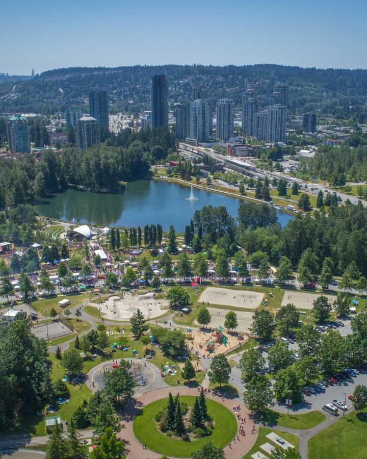
| City Centre | Coquitlam Centre, Lafarge Lake, Town Centre Park, City Hall, high-rise towers on the SkyTrain |
| Burquitlam and Lougheed | Fast-growing tower district on the Burnaby border; heart of Coquitlam's Korean community along North Road |
| Austin Heights | Shopping and cafes along Austin Avenue, Mundy Park, Como Lake |
| Maillardville | Historic francophone neighbourhood, Place des Arts, Mackin Park, Festival du Bois |
| Fraser Mills | New riverfront community on the old mill site |
| Southwest Coquitlam | Cariboo, Oakdale, Harbour Chines and Chineside, near Lougheed and Cape Horn |
| Central Coquitlam | Ranch Park, Mundy Park area, Riverview, Hockaday |
| Westwood Plateau | Hillside homes, Westwood Plateau golf course, Eagle Ridge, views of the inlet |
| Northeast Coquitlam | Burke Mountain (Partington Creek, Smiling Creek), River Springs, Coquitlam River trails |
Coquitlam Climate and Weather
Coquitlam has the mild, rainy oceanic climate typical of Metro Vancouver, but its position against the mountains makes it wetter than Vancouver or Surrey. Higher neighbourhoods such as Westwood Plateau and Burke Mountain get noticeably more rain and snow than City Centre or Maillardville.
| Season | Typical high | Typical low | What to expect |
|---|---|---|---|
| Winter (Dec–Feb) | 5–8 °C | 0–2 °C | Rainy, occasional snow, more at higher elevations |
| Spring (Mar–May) | 11–18 °C | 3–8 °C | Showers and blossoms |
| Summer (Jun–Aug) | 22–25 °C | 11–14 °C | Warm and dry, warmer than coastal Vancouver |
| Fall (Sep–Nov) | 9–20 °C | 3–10 °C | Warm September, heavy rain from October |
Figures are approximate, based on Environment and Climate Change Canada normals for the area.
Urban Planning in Coquitlam
Coquitlam's planning focuses growth around its SkyTrain stations, with high-rise towers in City Centre and Burquitlam, mid-rise buildings in Austin Heights and Maillardville, and new single-family and townhouse neighbourhoods on Burke Mountain. The city has used a "density bonus" program to collect money from developers for parks, community centres and affordable housing.
Key projects include the Burquitlam–Lougheed plan, the City Centre plan around Coquitlam Central and Lincoln stations, the Fraser Mills riverfront community, the Burke Mountain village and school sites, and the future of the historic Riverview lands with the Kwikwetlem First Nation. Housing affordability, traffic and keeping schools and services in step with growth are the main challenges.
Coquitlam Architecture and Landmark Buildings
| Building or site | Year | Why it matters |
|---|---|---|
| City Centre and Burquitlam towers | 2010s onward | New high-rise skyline along the SkyTrain line |
| Evergreen Cultural Centre | 1996 | Coquitlam's main performing arts centre and art gallery |
| Riverview Hospital buildings | 1913 onward | Grand heritage hospital buildings on a historic tree-filled campus |
| Mackin House | 1909 | Heritage home in Maillardville, now a museum |
| Our Lady of Lourdes Parish | Maillardville | Historic francophone Catholic parish |
| Fraser Mills | 1889 onward | Former giant sawmill site, now being redeveloped |
Coquitlam Demographics and Population
The 2021 census counted 148,625 people in Coquitlam, up almost 7% from 2016. About half of residents were born outside Canada and more than half belong to a visible minority group. Coquitlam has many families with children, especially on Burke Mountain and Westwood Plateau, while City Centre and Burquitlam attract young professionals and newcomers.
Ethnicity and Cultural Diversity
Coquitlam is one of the most diverse cities in Canada, and it has one of the highest shares of Korean residents of any Canadian city. The table shows approximate shares from the 2021 census.
| Group | Approximate share of residents |
|---|---|
| European origin | About 42% |
| Chinese | About 21% |
| Korean | About 8% |
| West Asian (mainly Iranian) | About 7% |
| South Asian | About 5% |
| Filipino | About 4% |
| Southeast Asian | About 2% |
| Latin American | About 2% |
| Indigenous (First Nations, Métis, Inuit) | About 2% |
| Black | About 1% |
| Japanese | About 1% |
Figures are rounded from the Statistics Canada 2021 Census Profile. North Road on the Burnaby border is known as Metro Vancouver's Koreatown, Persian grocers and restaurants are found across the city, and Maillardville keeps its French Canadian identity alive.
Languages Spoken in Coquitlam
English is the main shared language. The most common other languages are Mandarin, Korean, Persian (Farsi), Cantonese, Tagalog, Spanish, Russian and Punjabi. French has a long history in Maillardville, where many families have spoken it since 1909, and the city supports French immersion and francophone programs.
Religion in Coquitlam
Roughly 45% of residents reported no religion in 2021, and Christians make up about 40%, including many Catholic, Korean Presbyterian and Evangelical churches. Coquitlam also has a sizeable Muslim community, along with Buddhist, Sikh and Hindu residents. Our Lady of Lourdes in Maillardville and Our Lady of Fatima are among the city's historic parishes, and there are mosques and Islamic centres serving the Tri-Cities.
LGBTQ2S+ Coquitlam: Sexual Orientation and Gender Identity
Coquitlam has an inclusive and growing LGBTQ2S+ community. The City raises the Pride flag each year and supports Tri-Cities Pride events, and local groups, youth programs at community centres and the Coquitlam Public Library offer support and social activities. Most of the region's queer nightlife is in Vancouver, about 40 minutes away by SkyTrain.
Homelessness in Coquitlam
Homelessness in Coquitlam is counted together with Port Coquitlam and Port Moody as the Tri-Cities. The 2025 point-in-time count found about 144 people experiencing homelessness in the Tri-Cities, a 10% drop from 160 in 2023. However, fewer people were in shelter: 75 were sheltered and 69 were unsheltered, up from 62 unsheltered in 2023. Counts are always an undercount, since they miss people couch-surfing or living in vehicles.
The 3030 Gordon shelter and supportive housing in Coquitlam is the only permanent shelter in the Tri-Cities. Local churches run winter shelters, and the Tri-Cities Homelessness and Housing Task Group coordinates services across the three cities.
Coquitlam Economy and Major Employers
Coquitlam's economy is driven by retail, construction, health, education and professional services, with many residents commuting to Burnaby and Vancouver. Big employers include School District 43, the City of Coquitlam, Fraser Health, Douglas College and Coquitlam Centre's retailers.
Retail and food. Coquitlam Centre is one of the largest malls in the region, and Burquitlam's North Road is lined with Korean grocery stores and restaurants that draw shoppers from across Metro Vancouver.
Construction and real estate. Tower and townhouse construction around the SkyTrain stations and on Burke Mountain is one of the city's biggest industries.
Industry and logistics. The United Boulevard and Fraser Mills area along the Fraser River has warehouses, auto dealers, home furnishing stores and light industry.
Film. Coquitlam is one of the busiest filming cities in BC, largely thanks to the historic Riverview lands.
City Government, Mayor and Council
Coquitlam is governed by a mayor and eight councillors, all elected city-wide for four-year terms. Unlike Vancouver or Surrey, Coquitlam has no civic political parties; all members run as independents. Coquitlam voters also help elect trustees to the School District 43 board, which serves the Tri-Cities, Anmore and Belcarra. City Hall is at 3000 Guildford Way in City Centre.
Mayor and city councillors (term 2022–2026)
| Name | Role |
|---|---|
| Richard Stewart | Mayor (since 2008; not seeking re-election) |
| Brent Asmundson | Councillor |
| Matt Djonlic | Councillor |
| Craig Hodge | Councillor (running for mayor in 2026) |
| Steve Kim | Councillor |
| Trish Mandewo | Councillor |
| Dennis Marsden | Councillor |
| Robert Mazzarolo | Councillor |
| Teri Towner | Councillor |
The next civic election is Saturday, October 17, 2026. After 18 years in office, Mayor Richard Stewart is stepping down and has endorsed Councillor Craig Hodge to succeed him.
Other levels of government
Coquitlam is split among several federal and provincial ridings, including Coquitlam–Port Coquitlam and Port Moody–Coquitlam federally and Coquitlam-Burke Mountain and Coquitlam-Maillardville provincially. Drinking water, sewage treatment and regional parks are provided by Metro Vancouver, and TransLink runs transit.
Policing and Crime in Coquitlam
Coquitlam is policed by the Coquitlam RCMP, which serves Coquitlam, Port Coquitlam, Anmore and Belcarra from its detachment in City Centre. Port Moody has its own municipal police department. Metro Vancouver Transit Police patrol SkyTrain and the West Coast Express.
Coquitlam has relatively low crime rates for a city of its size. Most reported crime is property crime such as car break-ins, bike theft and shoplifting around busy shopping areas and transit hubs.
For emergencies call 9-1-1. For non-emergency police matters call Coquitlam RCMP at 604-945-1550.
Military in Coquitlam
Coquitlam has no Canadian Armed Forces base or reserve unit; the nearest reserve units are in New Westminster and Vancouver. Cadet units train locally, and Remembrance Day ceremonies are held each November 11 in Coquitlam and across the Tri-Cities.
Coquitlam Sister Cities
| City | Country | Relationship |
|---|---|---|
| Paju | South Korea | Sister city |
| Foshan | China | Friendship city |
Coquitlam wound down several older, inactive partnerships to focus on these two relationships.
Public Transport and Getting Around Coquitlam
| Line or route | Coquitlam stations or route | Good to know |
|---|---|---|
| SkyTrain Millennium Line (Evergreen Extension) | Burquitlam, Coquitlam Central, Lincoln, Lafarge Lake–Douglas | About 45 minutes from Coquitlam Central to downtown Vancouver |
| West Coast Express | Coquitlam Central Station | Weekday rush-hour commuter rail to downtown Vancouver and Mission |
| R3 Lougheed Highway RapidBus | Coquitlam Central to Maple Ridge | Frequent express service |
| Local buses | Coquitlam Central Exchange hub | Routes to Port Coquitlam, Port Moody, Burke Mountain and Westwood Plateau |
Driving
The Trans-Canada Highway (Highway 1) runs through southern Coquitlam to the Port Mann Bridge. The Lougheed Highway (Highway 7), Barnet Highway, United Boulevard, Pinetree Way and North Road are other major routes.
Cycling and walking
The Coquitlam River Trail, the Traboulay PoCo Trail loop, trails around Lafarge Lake and Mundy Park, and the steep Coquitlam Crunch stair trail are local favourites. A multi-use path runs alongside the Evergreen SkyTrain line.
Schools, Universities and Colleges in Coquitlam
Coquitlam is part of School District 43, one of the largest school districts in BC, serving Coquitlam, Port Coquitlam, Port Moody, Anmore and Belcarra. The district uses a three-level system of elementary, middle (grades 6 to 8) and secondary schools, and offers French immersion, International Baccalaureate, Advanced Placement and a large international student program. Rapid growth on Burke Mountain has led to new schools being built there.
Public secondary schools in Coquitlam
| School | Area |
|---|---|
| Centennial Secondary | Central Coquitlam (Mundy Park area) |
| Dr. Charles Best Secondary | Central Coquitlam |
| Gleneagle Secondary | Westwood Plateau area |
| Pinetree Secondary | City Centre |
Nearby SD43 secondary schools in Port Coquitlam and Port Moody, such as Riverside, Terry Fox, Port Moody and Heritage Woods, also serve Tri-Cities families. The francophone school École des Pionniers-de-Maillardville is in nearby Port Coquitlam. Independent schools include Our Lady of Fatima School and the Traditional Learning Academy.
Universities and colleges
| Institution | Type | Location |
|---|---|---|
| Douglas College, David Lam Campus | Public college and university transfer | City Centre, beside Lafarge Lake |
| Coquitlam College | Private university transfer college | Burquitlam |
| Simon Fraser University | Research university | Burnaby Mountain, minutes away |
Coquitlam Public Library
Coquitlam Public Library has two branches: the City Centre branch on Pinetree Way and the Poirier branch in central Coquitlam. Membership is free for residents and includes e-books, streaming, multilingual collections in Korean, Chinese and Persian, makerspace equipment and programs for all ages.
Arts and Culture in Coquitlam
Museums and galleries
| Venue | What you'll find | Area |
|---|---|---|
| Mackin House Museum | Local history in a 1909 heritage home | Maillardville |
| Art Gallery at Evergreen | Contemporary art exhibitions | City Centre |
| Coquitlam Archives | Historic photos and records, many online | City Hall |
| Place des Arts | Arts school and gallery in a heritage building | Maillardville |
Theatre and performing arts
| Venue | What's on |
|---|---|
| Evergreen Cultural Centre | Theatre, music, dance and comedy in a professional theatre |
| Place des Arts | Music and arts classes, recitals and exhibitions |
| Town Centre Park and Lafarge Lake | Outdoor summer concerts and festivals |
Filming locations in Coquitlam
The former Riverview Hospital is one of the most-filmed locations in Canada. Its grand old buildings and tree-lined grounds have appeared in The X-Files, Supernatural, Riverdale and many other films and series. Coquitlam's forests, lakes and suburban streets are also popular backdrops.
Media
- Local news: Tri-City News, Tri-Cities Dispatch, Freshet News
- Regional: CBC, CTV, Global BC and CityNews cover the Tri-Cities from Vancouver and Burnaby
- Korean and Persian media: Several Korean- and Persian-language newspapers and websites serve the local communities
Coquitlam Nightlife
Coquitlam's nightlife is about food, not clubs. Burquitlam's North Road is packed with late-night Korean barbecue, fried chicken, karaoke and dessert cafes. Austin Heights and City Centre have pubs and Persian, Chinese and Japanese restaurants. The Hard Rock Casino Vancouver, near Coquitlam's southern edge on United Boulevard, offers gaming and live concerts. For clubs and big nights out, most people take SkyTrain into Vancouver.
Parks and Gardens in Coquitlam
Coquitlam has more than 100 parks, plus huge wilderness areas to the north.
| Park | Why go |
|---|---|
| Lafarge Lake and Town Centre Park | Lake loop, playgrounds, sports, summer events and the Lights at Lafarge display |
| Mundy Park | Large forest park with lakes, trails and an outdoor pool |
| Como Lake Park | Small lake for walks and fishing |
| Minnekhada Regional Park | Marshes, lodge and rocky lookouts over the Pitt River |
| Colony Farm Regional Park | Wetlands, meadows and bird-watching along the Coquitlam River |
| Coquitlam River Park | Riverside trails and salmon viewing |
| Pinecone Burke Provincial Park | Large mountain wilderness for serious hiking |
| Burke Mountain trails | Forest trails and views on the city's northern edge |
| Blue Mountain Park | Forest, sports fields and a popular water park |
| Hoy Creek Linear Park | Creekside trails and fish hatchery near City Centre |
Natural Attractions In and Near Coquitlam
Coquitlam's "jungle" is temperate rainforest of cedar, hemlock and fir, which you can walk through in Mundy Park, along the Coquitlam River and on Burke Mountain. The Coquitlam Crunch is a steep 2.2 km stair-and-trail workout with views over the Fraser Valley. Nearby, Buntzen Lake (in Anmore), Belcarra Regional Park, Rocky Point Park in Port Moody and Widgeon Marsh offer swimming, kayaking and hiking within 20 minutes.
Things to Do in Coquitlam: Top Attractions
Top 10 places to visit in Coquitlam
- Lafarge Lake: easy lake loop and, in winter, the free Lights at Lafarge display.
- Mundy Park: big forest trails right in the city.
- Minnekhada Regional Park: marsh views and lookouts.
- Coquitlam Crunch: a famous local stair workout with a view.
- Burquitlam's Koreatown: Korean barbecue, bakeries and grocery stores.
- Maillardville: francophone heritage, Mackin House and Place des Arts.
- Riverview lands: historic buildings, arboretum and filming locations.
- Colony Farm Regional Park: bird-watching and river walks.
- Evergreen Cultural Centre: theatre, music and art.
- Coquitlam Centre: big shopping mall right on SkyTrain.
Full list of Coquitlam attractions
| Attraction | Area | Type |
|---|---|---|
| Blue Mountain Park | Central Coquitlam | Park, water park |
| Colony Farm Regional Park | South Coquitlam | Nature, birding |
| Como Lake Park | Austin Heights | Park, lake |
| Coquitlam Centre | City Centre | Shopping |
| Coquitlam Crunch | Westwood Plateau | Hiking trail |
| Evergreen Cultural Centre | City Centre | Theatre, gallery |
| Hard Rock Casino Vancouver | South Coquitlam | Casino, concerts |
| Lafarge Lake and Town Centre Park | City Centre | Park, events |
| Mackin House Museum | Maillardville | Museum |
| Minnekhada Regional Park | North Coquitlam | Nature park |
| Mundy Park | Central Coquitlam | Forest park |
| North Road Koreatown | Burquitlam | Food and shopping |
| Place des Arts | Maillardville | Arts centre |
| Riverview lands and arboretum | Riverview | Heritage, filming locations |
| Westwood Plateau Golf | Westwood Plateau | Golf |
Sports Teams and Recreation in Coquitlam
Teams
| Team | League | Venue |
|---|---|---|
| Coquitlam Express | BC Hockey League (junior A) | Poirier Sport and Leisure Complex |
| Coquitlam Adanacs | Western Lacrosse Association (senior box lacrosse) | Poirier Sport and Leisure Complex |
| Coquitlam Metro-Ford SC | Youth and adult soccer | Fields across Coquitlam |
Recreation facilities
Coquitlam's main facilities include the City Centre Aquatic Complex, the Poirier Sport and Leisure Complex (arenas, pool and fitness centre), Pinetree Community Centre, Glen Pine Pavilion, Dogwood Pavilion for seniors, the Place Maillardville community centre and new facilities on Burke Mountain. Percy Perry Stadium in Town Centre Park hosts track, football and soccer, and Mundy Park and Blue Mountain Park have outdoor pools and water play.
Annual Events and Festivals in Coquitlam
| Month | Event | Where |
|---|---|---|
| January–February | Lunar New Year celebrations | Coquitlam Centre and community centres |
| Late February–March | Festival du Bois, the largest francophone festival in Western Canada | Mackin Park, Maillardville |
| March | Nowruz (Persian New Year) celebrations | Venues across the Tri-Cities |
| July 1 | Canada Day celebrations | Town Centre Park |
| Summer | Summer concerts in the park | Town Centre Park and Lafarge Lake |
| September–October | Fall festivals and harvest events | Parks and community centres |
| November 11 | Remembrance Day ceremonies | Across the Tri-Cities |
| Late November–January | Lights at Lafarge, a free holiday light display | Lafarge Lake |
Dates change from year to year, so check with organizers before you go.
Sustainability and Green City Goals
Coquitlam's environmental plans focus on protecting its forests, creeks and salmon habitat, reducing greenhouse gas emissions from buildings and transportation, and adapting to climate risks such as heavy rain, flooding and wildfire smoke. The city protects large natural areas on Burke Mountain and along the Coquitlam River, requires low-carbon systems in new buildings, and is expanding EV charging and cycling routes. Restoring sockeye salmon to the Coquitlam River, together with the Kwikwetlem First Nation, is a long-term goal.
City Services and Amenities
| Service | How to reach it |
|---|---|
| City Hall | 3000 Guildford Way; 604-927-3000 |
| Emergency (police, fire, ambulance) | 9-1-1 |
| Coquitlam RCMP non-emergency | 604-945-1550 |
| HealthLink BC (nurse advice) | 8-1-1 |
| Garbage, recycling and green cart | Curbside collection; check the City's schedule |
| Nearest hospitals | Eagle Ridge Hospital (Port Moody) and Royal Columbian Hospital (New Westminster) |
Coquitlam FAQ
Is Coquitlam part of Vancouver?
No. Coquitlam is a separate city with its own mayor and council, and part of the wider Metro Vancouver region.
What are the Tri-Cities?
The Tri-Cities are Coquitlam, Port Coquitlam and Port Moody, three neighbouring cities in northeast Metro Vancouver, often grouped with the villages of Anmore and Belcarra.
How far is Coquitlam from downtown Vancouver?
About 45 minutes by SkyTrain from Coquitlam Central to Waterfront Station, or 30 to 45 minutes by car depending on traffic.
What is Coquitlam known for?
Its forests and trails, Lafarge Lake, Koreatown on North Road, the francophone heritage of Maillardville, Riverview filming locations and fast-growing SkyTrain neighbourhoods.
What is the population of Coquitlam?
The 2021 census counted 148,625 people, making Coquitlam the largest of the Tri-Cities.